Explore Trongsa - Bhutan Travel, Asia
Trongsa is a hidden gem of Bhutan waiting to be discovered. With its breathtaking landscapes and deep-rooted cultural significance, Trongsa is more than just a stopover on the way to eastern Bhutan. Strategically located on a ridge, Trongsa has played a central role in Bhutan's history and is an important tourist destination of Bhutan’s untouched beauty and rich cultural heritage. It offers travelers a chance to dive into the kingdom's history, surrounded by dramatic mountain views and the timeless charm of traditional Bhutanese architecture.
Population: Approximately 20,000 in 2017.
Economy: Trongsa's economy is mostly based on agriculture, with locals cultivating crops like rice and maize. Tourism also plays a key role, supported by its rich history and cultural significance.
Landmarks: Famous for the Trongsa Dzong, Ta Dzong, and the Chendebji Chorten.
Bhutan
Overview of Trongsa
History & Cultural Influence
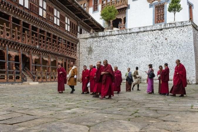
Trongsa holds a significant place in Bhutan's history and culture, serving as a strategic and historical center for centuries. At the heart of Trongsa’s cultural and historical significance is Trongsa Dzong, one of the largest and most majestic fortresses in Bhutan, playing a significant role in the country’s monarchy. Trongsa is also a spiritual hub, with its many monasteries and temples contributing to Bhutan’s deeply Buddhist culture. Ta Dzong, the former watchtower, now serves as a museum that showcases the royal history of Bhutan and stunning displays of traditional Bhutanese art.
Interaction with The Locals
Trongsa is a small town in central Bhutan where the citizens are predominantly Bhutanese, with a strong cultural connection to their traditions and Buddhist beliefs. Most locals wear the traditional attire, gho for men and kira for women, especially during festivals and religious ceremonies. The people are known for their warm hospitality, deeply rooted in their sense of community and spiritual practices. Living in a region rich in history, the residents of Trongsa proudly uphold their heritage while maintaining close ties to their royal and religious past.
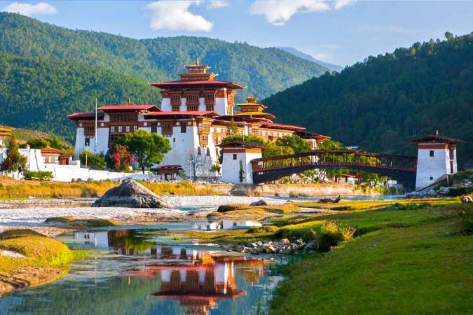
Trongsa Dzong - © CafeF
Top Attractions in Trongsa
Trongsa Dzong
No visit to Trongsa is complete without exploring Trongsa Dzong. This massive fortress dominates the landscape and is a stunning example of traditional Bhutanese architecture. Built on a ridge, its many levels, courtyards, and temples offer visitors a journey through Bhutan's past. The views from the Dzong are equally mesmerizing, with dramatic valleys stretching far below.
Ta Dzong
Just above Trongsa Dzong is Ta Dzong, a former watchtower now transformed into a fascinating museum. It houses exhibits that offer insights into Bhutan’s royal family, Buddhism, and the military history of the region. The museum’s highlights include a collection of rare artifacts, intricate Buddhist statues, and displays that chronicle Bhutan’s religious and political history.
Chendebji Chorten
A short drive from Trongsa brings visitors to Chendebji Chorten, a peaceful site modeled after the famous Swayambhunath Stupa in Nepal. Built to ward off evil spirits, this sacred stupa attracts both pilgrims and tourists who seek peace and spiritual reflection. The serene setting, combined with the spiritual atmosphere, makes it a must-see for those looking to experience Bhutan’s religious devotion.
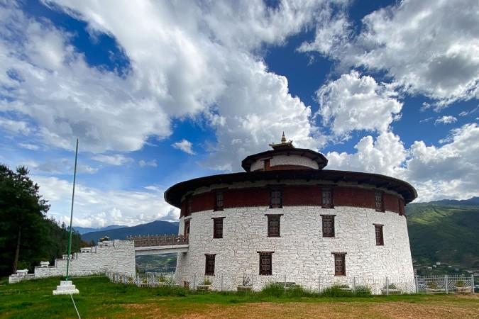
Ta Dzong - © Asian Historical Architecture
Must-Try Dishes in Trongsa
Trongsa offers a delightful culinary journey with its traditional Bhutanese dishes, blending bold flavors and hearty ingredients. Most meals are centered around rice, accompanied by a variety of stews, meat dishes, and fiery chilies, showing the best of local Bhutanese cuisine.
- Ema Datshi: Ema Datshi is Bhutan’s beloved national dish, made with chilies and local cheese. Spicy and rich, this dish is a staple in almost every Bhutanese meal and is served with rice.
- Phaksha Paa: Phaksha Paa is another popular dish in Trongsa, combining slices of pork with dried red chilies, radishes, and sometimes spinach. This savory and slightly spicy dish is often accompanied by rice and is enjoyed for its robust flavors and filling nature.
- Jasha Maru: Jasha Maru is a flavorful and spicy chicken dish made with diced chicken, tomatoes, garlic, ginger, and lots of chilies, this dish is typically served with rice. The juicy chicken combined with the fresh vegetables creates a dish that’s both satisfying and nutritious.
- Hoentay: Hoentay is a specialty dish from the northern regions of Bhutan but is widely enjoyed in Trongsa as well. These buckwheat dumplings are filled with spinach, turnip greens, and cheese, and are usually steamed or fried.
- Khur-le: Khur-le are traditional Bhutanese pancakes made from buckwheat, wheat, or barley flour. Often served during breakfast, these pancakes are typically eaten with butter or cheese.
- Suja: To complement your meal, try a cup of Suja, Bhutan’s traditional butter tea. This unique drink is made from tea leaves, butter, and salt, providing a rich, savory flavor. While it may be an acquired taste for some, it’s an essential part of Bhutanese culture, particularly in colder regions like Trongsa.

Jasha Maru - © Little Bhutan - Happy Flavour
Festivals & Local Celebrations
Trongsa Tshechu
Trongsa Tshechu is held annually in December or January at the majestic Trongsa Dzong. This religious festival is a grand spectacle of color, music, and spirituality, drawing both locals and tourists to witness the traditional masked Cham dances. These dances are performed by monks and laymen, depicting stories from Bhutanese mythology and Buddhist teachings. The festival is deeply spiritual, as it is believed to bring blessings, ward off evil spirits, and ensure good fortune for the coming year.
Jakar Tshechu
Although not directly in Trongsa, the Jakar Tshechu, held in nearby Bumthang, is another significant festival that travelers can attend while in the region. Like the Trongsa Tshechu, the Jakar Tshechu also features Cham dances and religious rituals performed to honor the teachings of Guru Rinpoche, the patron saint of Bhutan. This festival takes place in October or November and provides a fantastic insight into Bhutan’s religious practices and the way locals come together to celebrate their shared heritage.
Chökhor Duchen
Chökhor Duchen is another important religious celebration in Bhutan, including Trongsa. This festival marks the day when the Buddha first turned the wheel of Dharma (his first teaching after attaining enlightenment). Held in July or August, locals gather in monasteries to pray, offer butter lamps, and perform religious rituals. While the festival is quieter than the more prominent Tshechus, it holds great spiritual importance for the Bhutanese people. Visitors are welcome to observe these sacred rituals and even participate in the lighting of butter lamps, symbolizing the removal of darkness and ignorance.
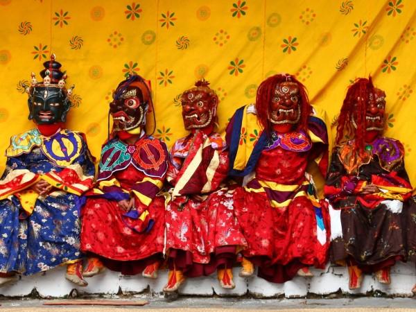
Trongsa Tshechu - © Tourism Bhutan
What to Do in Trongsa
- Trekking in Trongsa: The region offers several scenic trekking and hiking routes that lead travelers through lush forests, terraced fields, and remote villages. One of the most popular trails is the hike to the remote Kuenga Rabten Palace, a historic retreat of the royal family. For those seeking a more challenging trek, the trails around Yutong La Pass offer a mix of dense forests and sweeping mountain views, providing a rewarding adventure for outdoor enthusiasts.
- Trongsa Cultural Tours: Trongsa has extensive cultural trips that take you through its historical and religious attractions. A guided tour of Trongsa Dzong and Ta Dzong gives visitors a deeper understanding of Bhutan’s monarchy and Buddhist traditions. These tours often include visits to local monasteries, where you can observe monks engaged in their daily rituals.
- Birdwatching in Trongsa: Trongsa’s diverse landscape is home to a variety of bird species, making it an ideal destination for birdwatching. Travelers can spot rare birds such as the Himalayan Monal, Blood Pheasant, and other endemic species as they explore the forests around the town.
Shopping in Trongsa
- Local Markets: Explore the vibrant local markets in Trongsa, where you can find traditional Bhutanese goods such as handwoven textiles, wooden crafts, and local produce. These markets provide an authentic shopping experience and the opportunity to connect with local craftspeople.
- Handicraft Stores: Visit small handicraft stores around the town that specialize in Bhutanese souvenirs like intricately carved wooden masks, traditional thangka paintings, and handcrafted jewelry. These shops are perfect for finding unique, locally made gifts.
- Textile Shops: Trongsa is known for its beautiful woven fabrics. Textile shops in the area offer handwoven kiras and ghos (traditional Bhutanese attire), as well as scarves and other items crafted with traditional techniques.
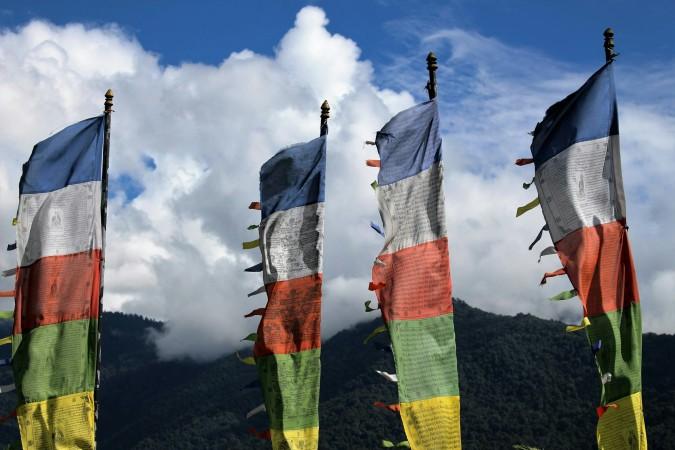
- Monastery Gift Shops: Some monasteries in the region have small gift shops where you can purchase religious items such as prayer flags, statues, and incense. These shops often carry items that support the monastery and its upkeep.

Natural beauty of Trongsa - © World Travel Magazine
Weather in Trongsa: Best Time to Visit
Spring in Trongsa
Spring is one of the best times to visit Trongsa, with temperatures ranging between 10°C to 20°C (50°F to 68°F). The weather is mild and comfortable, perfect for outdoor activities such as trekking and sightseeing. During this season, the landscape comes alive with blooming flowers, making it an ideal time for nature enthusiasts to explore the lush greenery and vibrant wildflowers.
Summer in Trongsa
Summer in Trongsa is characterized by warm temperatures, ranging from 15°C to 25°C (59°F to 77°F), but it’s also the monsoon season. July and August see the heaviest rainfall, which can sometimes disrupt travel plans due to muddy roads and landslides. However, if you're a fan of lush, green landscapes, the monsoon brings the countryside to life, making it a great time for photography and enjoying Bhutan's natural beauty.
Autumn in Trongsa
Autumn is another popular season to visit Trongsa, with clear skies and crisp air. Temperatures range from 10°C to 18°C (50°F to 64°F), making it an excellent time for trekking and exploring the region’s many historical sites. The colorful autumn foliage provides a stunning backdrop for outdoor adventures. This season is also ideal for attending local festivals like the Trongsa Tshechu.
Winter in Trongsa
Winter in Trongsa brings cold temperatures, often dipping between 0°C and 10°C (32°F to 50°F). Nights can be particularly chilly, with frost in the early mornings. However, the days are usually dry and sunny, making it a peaceful time for those who prefer cooler weather and fewer tourists. Although outdoor activities are limited due to the cold, the clear skies provide excellent views of the snow-capped mountains.
Buddhist Monks at Trongsa Dzong - © PhotoHound
Essential Travel Information
Getting Around Trongsa
- Local Taxis: Once at Trongsa, cabs are the most convenient way to get around town and see neighboring sights. Taxis can be hailed from the town center or arranged through your accommodation. They are generally affordable for short distances and offer a flexible option for visiting places like Trongsa Dzong, nearby temples, or local markets.
- Walking and Hiking: Trongsa’s compact size makes it easy to explore parts of the town on foot. Walking is an enjoyable way to soak in the local culture, visit small shops, or simply enjoy the views of the mountains. For travelers interested in nature, hiking trails around Trongsa are accessible from the town, offering an active and scenic way to explore the region.
- Motorbike or Bicycle Rentals: For the more adventurous, renting a motorbike or bicycle is an option to explore off-the-beaten-path locations in Trongsa. This gives you the freedom to travel independently and at your own pace. Keep in mind that the hilly terrain can be challenging, so this option is best suited for experienced riders or cyclists who are comfortable navigating Bhutan’s mountain roads.
ATM & Banking Services
In Trongsa, there are a few ATMs available, but they can sometimes be unreliable due to connectivity issues or cash shortages, especially during busy tourist seasons. It is advisable to withdraw enough cash in larger towns like Thimphu or Paro before traveling to Trongsa. Currency exchange services are limited in Trongsa, so it’s best to exchange money in advance in major cities. While some high-end hotels may accept credit cards, most local businesses and smaller establishments operate on a cash-only basis, making it important for travelers to carry sufficient local currency for daily expenses.
Where to Stay in Trongsa
- Hotels & Guesthouses: Trongsa offers a range of lodging options, from budget-friendly guesthouses to mid-range hotels. Many of the accommodations in Trongsa offer stunning views of the surrounding mountains and valleys, giving travelers a peaceful retreat after a day of exploring. These hotels and guesthouses often offer basic services like Wi-Fi, hot water, and on-site food, making them an easy choice for most guests.
- Homestays: If you’re looking for a more immersive experience, staying at a local homestay is a fantastic option. Homestays offer a chance to experience authentic Bhutanese life by staying with a local family. You’ll be able to enjoy home-cooked meals and engage with the family, learning more about Bhutanese customs and traditions.
Articles for you
Explore Yala National Park - Sri Lanka Travel, Asia
Tucked away in Sri Lanka’s southeastern corner, Yala National Park is where wild nature meets deep tradition. Known worldwide for its leopard population, the park is also home to elephants, sloth bears, crocodiles, and hundreds of bird species. Beyond wildlife, Yala opens doors to a cultural landscape dotted with ancient temples, Buddhist ruins, and coastal villages. For travelers seeking more than just a safari, Yala offers a chance to explore eco-tourism, local communities, and sacred heritage sites.
Population: The Yala National Park area doesn’t have a human population.
Economy: The economy around Yala National Park thrives on a blend of eco-tourism, agriculture, and local services. Safari tours, eco-lodges, and cultural experiences drive steady income for nearby towns like Tissamaharama and Kataragama, supporting thousands of families.
Landmarks: Famous for Block I of Yala and wildlife encounters, including elephants, sloth bears, crocodiles, and exotic bird species.
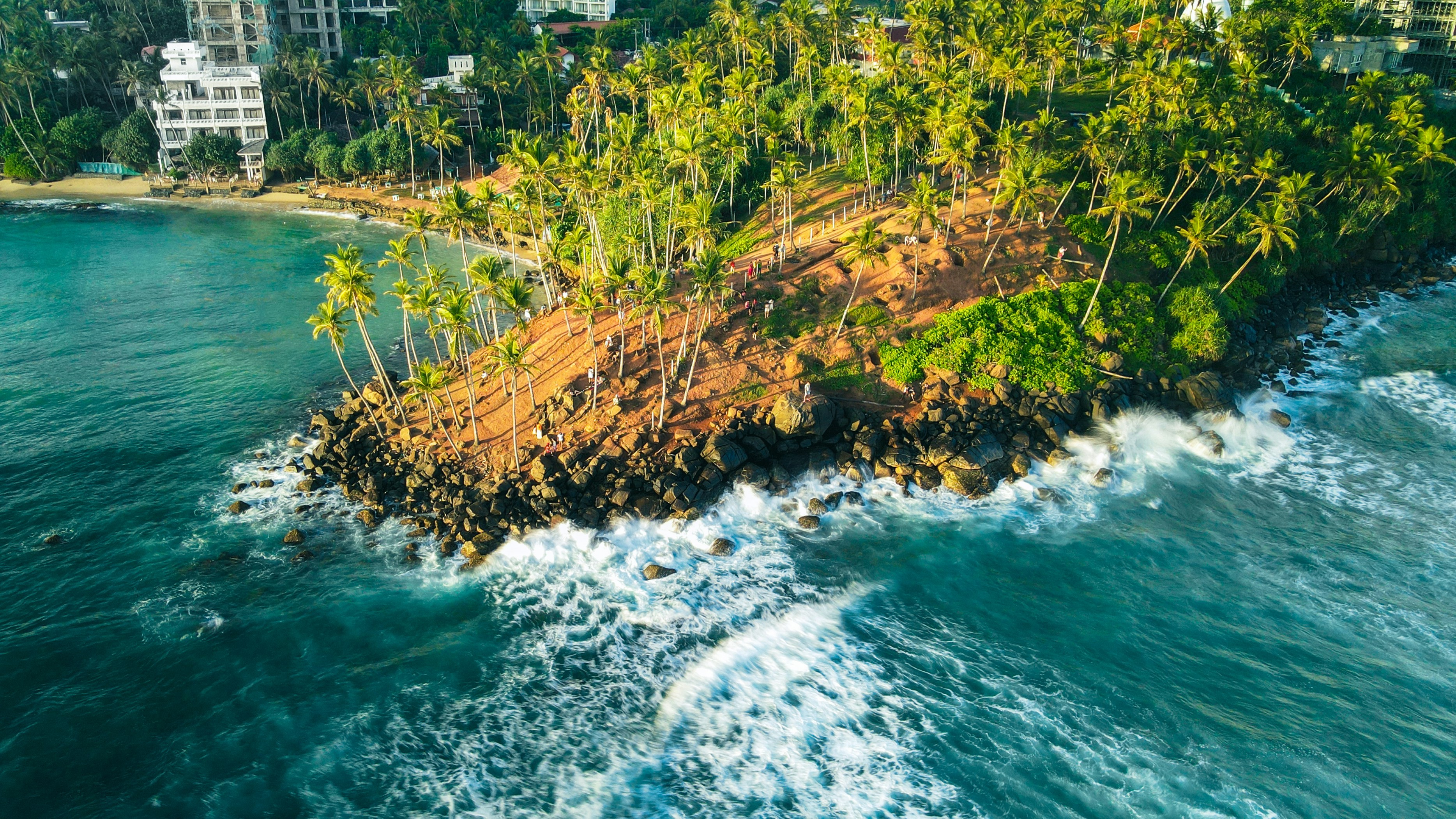
Explore Galle - Sri Lanka Travel, Asia
Nestled on Sri Lanka’s southern coastline, Galle is a vibrant city where history meets the sea. Its cobbled streets, colonial architecture, and serene beaches make it a must-visit destination for travelers seeking a blend of culture, adventure, and relaxation. A UNESCO World Heritage site, Galle captivates visitors with its Dutch Fort, bustling markets, and friendly locals. Whether you’re exploring the ramparts at sunset or savoring fresh seafood by the shore, Galle promises an unforgettable journey into Sri Lanka’s heritage.
Population: Approximately 113,000 in 2023.
Economy: Galle’s economy thrives on tourism, trade, and fisheries. The city’s historic fort, colonial architecture, and coastal charm draw thousands of international visitors each year, making tourism its main economic driver. Fishing remains vital for local livelihoods, supplying fresh seafood across the region.
Landmarks: Famous for the Galle Fort, Dutch Reformed Church & Maritime Museum, and Unawatuna Beach.
Explore Bentota - Sri Lanka Travel, Asia
Nestled along Sri Lanka’s southwestern coast, Bentota is a tropical paradise that blends golden beaches, vibrant culture, and thrilling adventures. Famous for its calm waters, luxury resorts, and scenic river estuary, Bentota has become a top destination for travelers seeking both relaxation and authentic experiences. From serene beach walks at sunrise to adrenaline-pumping water sports, this coastal town offers a perfect balance of leisure and exploration. With its proximity to Colombo and Galle, Bentota is easy to reach, making it an ideal stop for both short escapes and extended holidays.
Population: Approximately 37,000 in 2023.
Economy: Bentota’s economy thrives mainly on tourism, which drives local businesses such as hotels, restaurants, and wellness retreats. The town also benefits from fishing, coconut cultivation, and handicrafts like wood carving and batik textiles. Many residents rely on the growing demand for water sports and Ayurvedic treatments, making tourism the backbone of both income and employment in the area.
Landmarks: Famous for Bentota Beach, Bentota River Safari, and Kande Vihara Temple.
Explore Mirissa - Sri Lanka Travel, Asia
Mirissa is a charming coastal town on Sri Lanka’s southern shoreline. Known for its golden beaches, turquoise waters, and vibrant marine life, it has become a must-visit stop for travelers exploring the island. Many come for whale watching, surfing, and sunset views at Coconut Tree Hill, but Mirissa offers much more than postcard beauty. The fishing boats you see anchored by the bay carry generations of stories. Local traditions, delicious cuisine, and a laid-back rhythm of life shape every visitor’s experience.
Population: Approximately 4,700 in 2023.
Economy: Mirissa’s economy is largely shaped by its coastal location. Fishing has long been the backbone of local livelihoods, with generations relying on the Indian Ocean for income. In recent decades, tourism has become the main driver of growth, thanks to whale watching, surfing, and beachside hospitality.
Landmarks: Famous for Mirissa Beach, Coconut Tree Hill, and Parrot Rock Bridge.
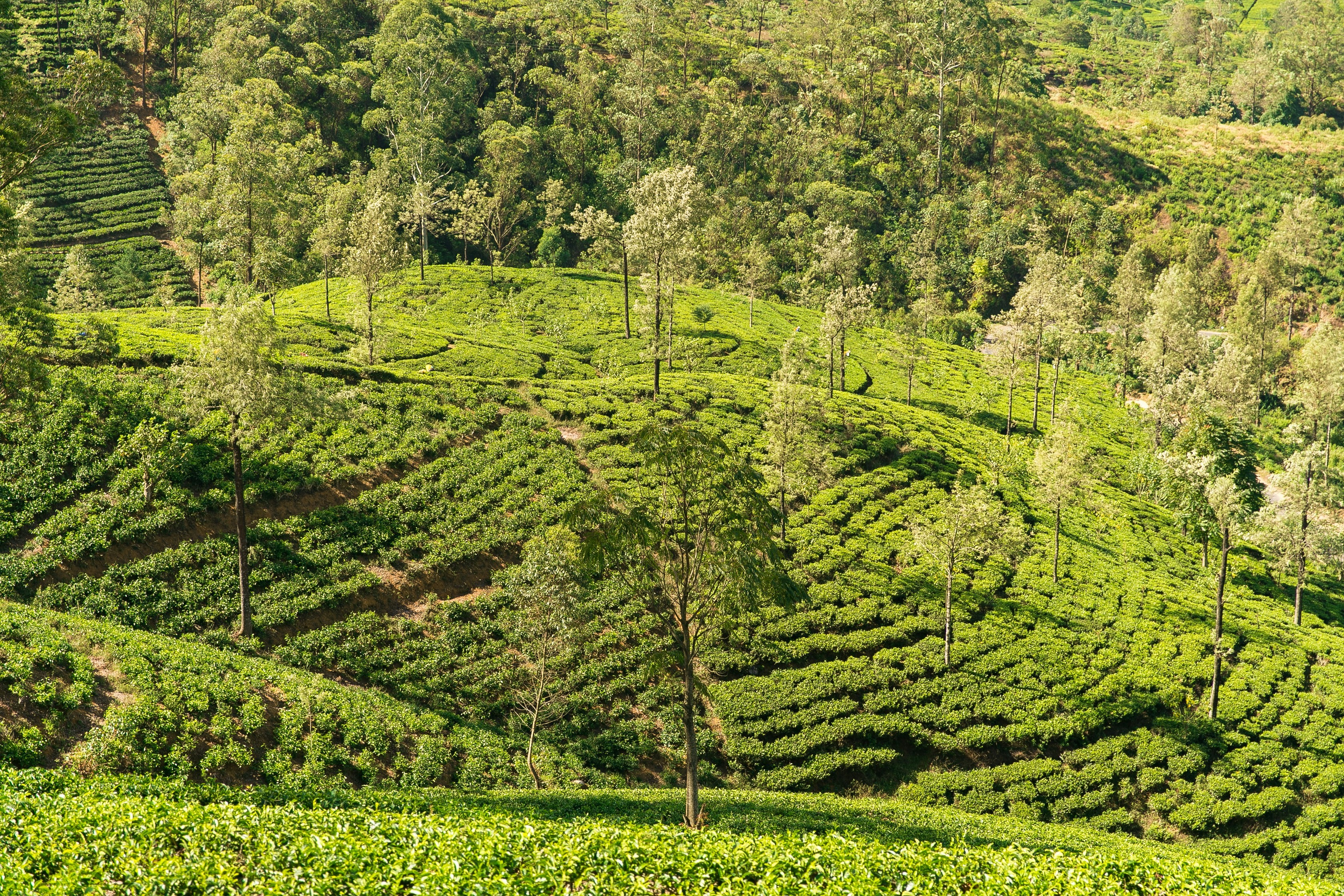
Explore Nuwara Eliya - Sri Lanka Travel, Asia
Tucked away in the Central Highlands of Sri Lanka, Nuwara Eliya is often called “Little England”. With its rolling tea plantations, cool misty mornings, and colonial charm, this mountain town feels like a step into another world. Travelers come here to breathe fresh air, walk through flower gardens, sip the finest Ceylon Tea, and enjoy a pace of life far from the island’s busy cities. Whether you’re drawn by scenic landscapes, heritage architecture, or the warmth of its people, Nuwara Eliya is a destination that blends nature, culture, and history in perfect harmony.
Population: Approximately 781,000 in 2023.
Economy: Nuwara Eliya’s economy thrives mainly on tea production, as it sits in the heart of Sri Lanka’s central highlands, famous worldwide for Ceylon Tea. The city also benefits from a growing tourism industry, attracting visitors with its colonial charm, cool climate, and scenic landscapes.
Landmarks: Famous for Gregory Lake, Hakgala Botanical Garden, and Victoria Park.
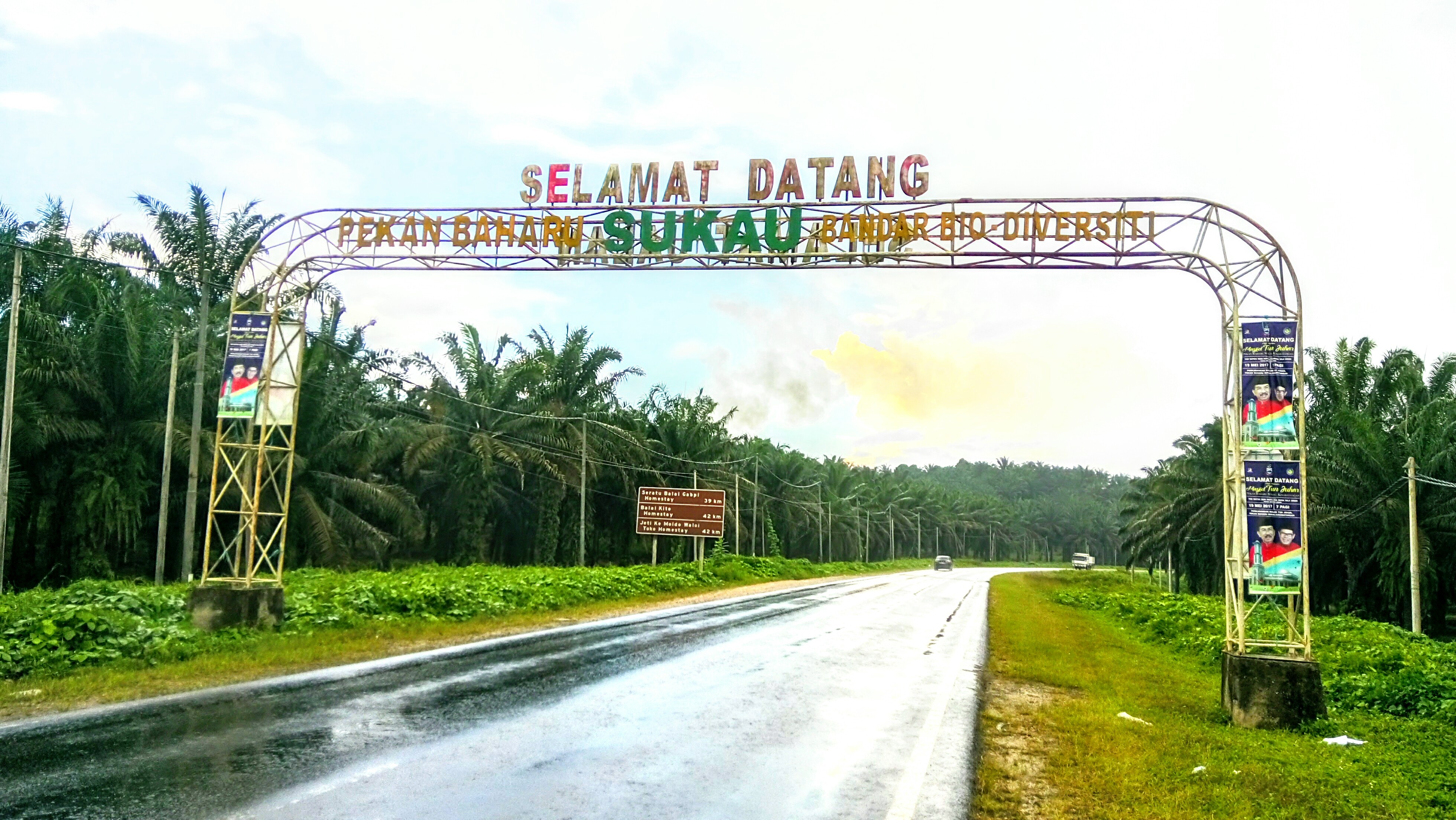
Explore Sukau - Malaysia Travel, Asia
Nestled on the banks of the Kinabatangan River in Sabah, Malaysian Borneo, Sukau is a destination where wildlife, culture, and conservation come together. Known as one of Asia’s top spots for river safaris and eco-tourism, this quiet village offers a front-row seat to encounters with Bornean orangutans, pygmy elephants, proboscis monkeys, and exotic birdlife.
Population: Approximately 1,400 in 2019.
Economy: Sukau’s economy is shaped by its riverine location and natural resources. Traditionally, the Orang Sungai community relied on fishing, small-scale farming, and forest gathering for their livelihood. Today, the village has shifted toward eco-tourism, with river cruises, jungle trekking, and homestays providing income.
Landmarks: Famous for the Kinabatangan River cruises, Gomantong Caves, and Ox-bow lakes and wetlands.
Follow Us
